OsmAnd+ — Maps & GPS Offline

OsmAnd+ — Maps & GPS Offline

OsmAnd
Advertisement
4.6
Travel & Local
100,000+ Downloads

Click to download now, finish the installation quickly, and directly unlock the "all-round experience"
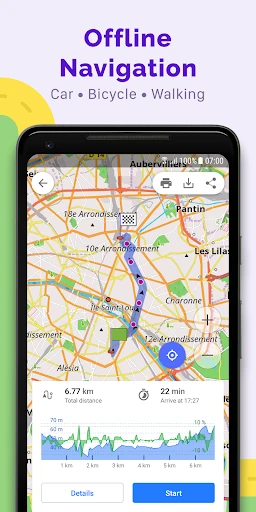
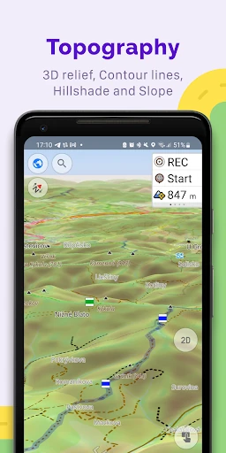
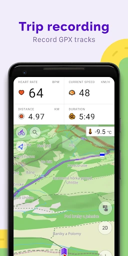
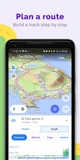
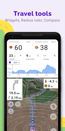
Advertisement

Screenshots

Screenshot
Screenshot
Screenshot
Screenshot
Screenshot
Screenshot
Screenshot
Screenshot
Screenshot

About This App

🏆 Expert Verdict & Overview

OsmAnd+ — Maps & GPS Offline stands as a formidable outlier in the Travel & Local category, eschewing cloud dependency for unparalleled user autonomy. It is less a simple navigation aid and more a comprehensive, open-source geo-platform offering professional-grade tools for planning, exploring, and recording journeys entirely offline. Its core value proposition is a complete digital map and routing system that resides in the user's pocket, independent of data networks, built upon the collaborative OpenStreetMap (OSM) project. This positions it as the definitive choice for adventurers, international travelers, and privacy-conscious users who require reliable, detailed geographical intelligence beyond the reach of standard online services.

🔍 Key Features Breakdown

  • Fully Offline OSM Maps: By leveraging OpenStreetMap data, OsmAnd+ provides a globally consistent and often more detailed map foundation than commercial alternatives, solving the critical problem of navigation in areas with poor or expensive cellular coverage, ensuring users are never stranded without a map.
  • Unlimited Map Downloads & Hourly Updates (Paid): Directly addresses the limitation of most offline apps by allowing users to download entire countries or continents. The ability to update map data rapidly ensures information remains current, a vital feature for planning active trips.
  • Advanced, Customizable Routing: It empowers users with fine-grained control over navigation by allowing route adjustments for vehicle dimensions, excluded roads, and surface types. This solves complex logistical planning problems for cyclists, truckers, hikers, and off-road enthusiasts that generic apps cannot handle.
  • Multi-Functional Point Creation & GPX Management: Transcends basic 'favorites' by enabling audio/video notes and markers, while the robust GPX track import, recording, and sharing features solve the need for precise activity logging, route planning, and even contributing data back to the OSM community.
  • Rich Data Overlays (Topo, Nautical, Wiki): The integration of contour lines, terrain shading, depth charts, and offline Wikipedia/Wikivoyage articles transforms the app from a navigator into an interactive travel guide. This solves the explorer's need for contextual, encyclopedic information about their surroundings without an internet connection.
  • User Privacy & Open-Source Foundation: Mitigates growing concerns over data collection by being transparently open-source, giving users ultimate control over app permissions, and storing all sensitive data locally. This fundamentally solves the privacy dilemma inherent in most location-based services.

🎨 User Experience & Design

The interface presents a classic trade-off between power and approachability. It offers immense customization, from map styles (touring, nautical, ski) to configurable on-screen widgets, catering to highly specific use cases. However, this flexibility results in a dense, information-rich UI with a steep initial learning curve, diverging from the minimalist, opinionated design of mainstream consumer apps like Google Maps. The UX prioritizes functionality and user control over guided simplicity. Once mastered, it provides an exceptionally efficient workflow for power users, but it demands a higher investment of time and exploration from the casual user compared to category standards, which prioritize immediate intuitive use above all else.

⚖️ Pros & Cons Analysis

  • ✅ The Good: Complete offline functionality for maps, search, and routing provides ultimate reliability and data cost savings.
  • ✅ The Good: Unmatched depth of features for outdoor and specialized navigation (cycling, hiking, boating).
  • ✅ The Good: Strong commitment to user privacy and data ownership through its open-source model.
  • ✅ The Good: Highly customizable map display and navigation profiles for tailored user experiences.
  • ❌ The Bad: Steep learning curve due to a complex, feature-packed interface can overwhelm new users.
  • ❌ The Bad: Map data quality and points-of-interest information are dependent on the volunteer-driven OSM project and can be inconsistent in less-mapped regions.
  • ❌ The Bad: Voice guidance and real-time traffic (where available) are generally less polished than in premium commercial navigation suites.

🛠️ Room for Improvement

To broaden its appeal without sacrificing core power, the next iterations should focus on a tiered user experience. Implementing a dynamic, interactive onboarding tutorial that introduces core features contextually would dramatically reduce initial friction. Enhancing the default "Automatic" navigation profile with smarter, context-aware suggestions (e.g., simpler routing for first-time users, advanced options for experts) could serve both audiences. Furthermore, investing in more natural-sounding, variable-option voice guidance and a more streamlined process for suggesting missing OSM points-of-interest directly from the app would significantly improve the out-of-the-box experience for the everyday traveler.

🏁 Final Conclusion & Recommendation

OsmAnd+ is emphatically not for everyone. It is a specialist tool designed for a specific target audience: serious travelers, outdoor adventurers (hikers, cyclists, sailors), digital nomads, urban planners, and privacy advocates who require robust, self-contained navigation tools. For the casual user needing simple A-to-B driving directions, a mainstream app will be more immediately satisfying. However, for its intended users, OsmAnd+ is an indispensable, empowering platform that offers freedom, privacy, and a depth of functionality unmatched in the consumer market. Our final verdict is a strong recommendation for any user whose travel needs extend beyond the paved road and the cellular grid.